Overview
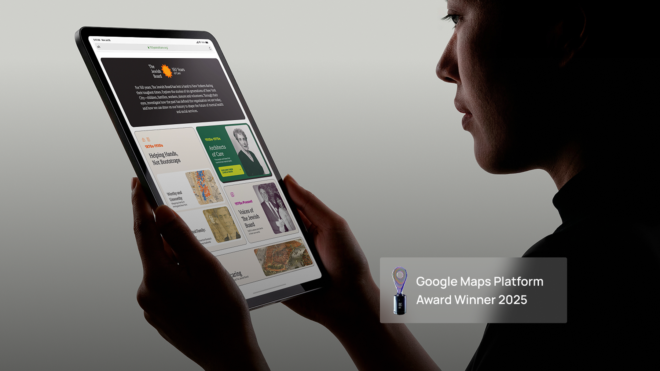
150yearsofcare.org commemorates The Jewish Board’s 150-year legacy of providing mental health and social services in New York City. At the heart of the project is “Worthy and Unworthy”, an interactive digital map overlaying 1,500+ historic addresses from 1899 onto present-day New York, allowing users to explore the geography of poverty and philanthropy in 19th-century Manhattan. The project won the first-ever Google Maps Platform Award, recognising it as one of the most impactful and technically excellent uses of Google Maps Platform globally.
Client
The Jewish Board, New York (via Marapachi Design Studio)
Industry
Heritage • Social Services
Geography
United States
Our Role
Tech
The client
The Jewish Board is one of New York City’s largest and most established social services organisations, providing mental health, developmental disabilities, and community services to tens of thousands of New Yorkers. In 2024, the organisation commemorated 150 years of care with a digital project that brought their history to life in a way no archive or brochure could.
The story behind the project
In 1899, a young clerk named Louis Lewengood prepared a booklet for the United Hebrew Charities in New York City. Inside were the names and addresses of more than a thousand Jewish immigrants who had received aid, alongside the names of the donors who had helped them. This modest record revealed something profound: the geography of poverty and philanthropy in 19th-century Manhattan.
When Marapachi Design Studio approached Awsm to develop the project, we knew this was not just about plotting old addresses on a map. It was about giving voice to forgotten lives, visualising the social divides of a growing city, and transforming static archives into something living, searchable, and human.
What we build
150yearsofcare.org
A commemorative website on WordPress built to mark The Jewish Board’s 150-year anniversary. Through narratives spanning six generations, the site highlights the organisation’s evolution and impact on children, families, workers, donors, and volunteers across New York City.
“Worthy and Unworthy” — The Award-Winning Interactive Map
The centrepiece of the project. An interactive digital map overlaying 1,500+ historic addresses from 1899 onto present-day New York City, allowing users to see, filter, and compare where charity recipients and donors lived. The patterns revealed are striking: the geography of need and philanthropy rarely overlapped.
What users can do:
- Filter by charity recipient or donor
- Search by donation amount or charity type
- Compare historic and modern addresses side by side
- View scanned images of original handwritten ledger entries from 1899
- Explore the social and geographic divides of 19th-century Manhattan
Designed with a clean, retro aesthetic that respects the historical nature of the data while keeping the experience accessible and engaging for modern audiences.
Technical Implementation
Google Maps JavaScript AP
The entire map interface is built on the Google Maps JavaScript API with custom styling to match the historical tone of the project.
Data Digitisation and Geocoding
Original ledger data was digitised, cleaned, and geocoded to plot over 1,500 historic addresses precisely across Manhattan. Many addresses no longer exist, terms were outdated, and the data had gaps. Each was researched and resolved with patience and accuracy.
Custom Filtering Engine
A purpose-built filtering system enables fluid exploration of the dataset by year, category, recipient type, and more, with smooth performance on both desktop and mobile.
Interactive Overlay System
Pop-ups display names, addresses, donation or aid details, and original scanned ledger entries, connecting present-day users directly to the historical record.
Responsive Design
Fully accessible across devices, ensuring the map performs smoothly on desktop and mobile without compromise.
The design partnership
The visual design of the project was crafted by Bharat KV of Marapachi Design Studio, built on a Bento layout system. The design balances historical sensitivity with modern usability, a combination that was central to the project’s success and its recognition by Google.
The challenge
Balancing historical sensitivity with modern usability was the defining challenge. Addresses from 1899 no longer exist on current maps. Historical terminology needed careful handling. Data gaps required research and judgement calls. Every decision needed to honour the dignity of the individuals in the records while keeping the experience technically sound and performant.
The recoginition
In 2025, this project won the first-ever Google Maps Platform Award, presented by Google to recognise projects that push the boundaries of creativity and technical excellence using the Google Maps Platform.
To be the first-ever winner of this award is not just a technical achievement. It is recognition that maps can do more than navigate, they can tell stories, surface forgotten truths, and connect the present to the past in ways that matter.
For a small, close-knit team without a marketing department or promotional campaigns, this award is a reflection of what has always been true at Awsm: passionate, talented people can make a global impact.
This award belongs to every member of our team. Behind every pixel mapped and every dataset refined lies dedication, creativity, and relentless problem-solving.
Technology
Results
- Winner of the first-ever Google Maps Platform Award, presented by Google
- 1,500+ historic addresses from 1899 geocoded and mapped onto present-day New York
- A living archive connecting generations of New Yorkers to a shared history
- A project that demonstrates maps as a medium for storytelling, empathy, and historical discovery